Wednesday, August 31, 2011

Galway and Connemara

I think we would have loved Galway. Except it rained our entire 40 hours. And not just the misty type rain that is merely annoying, but full on, pavement pounding rain. Do you know what doesn't keep that kind of rain out? A collapsible, travel umbrella that only cost 6 euros and an only slightly more expensive jacket in a packet. In an effort to not break our streak of nightly pub music, we did shuttle off to a yummy dinner (at Ard Bia, highly recommend it!) and then a pub, where we lasted about 20 minutes. We did not walk through the romantic streets, down the pedestrian pathways, or take in the city park. But I'm sure the city is lovely. Just sure of it.
We'd originally planned a huge driving day throughout the entire region, but since we'd had several big driving days in a row, our new plan was to just enjoy Galway. One look out the window and a quick check of the weather forecast, and it was back to a modified Plan A. We decided to head through the Connemara region up to Kylemore Abbey, mainly because we heard it had a nice, little cafeteria with tea and scones. Don't tea and scones sound wonderful for a gray, rainy day? Kylemore Abbey did not disappoint, and the gray skies only added atmosphere to the Gothic architecture. It was perfect...not really, but I tried to make the best of weather conditions to which I am not suited.
The drive around the region was beautiful - remote, quiet, full of lakes and waterfalls spilling down the hills.

Tuesday, August 30, 2011

Where Did All These People Come From!

You can't actually see all the people in my photos. They really were there, really.
 From beautiful, relaxing, tranquil Dingle, we drove straight into what seemed like a Florida beach during Spring Break. There were more people just on the Cliffs of Moher (pronounced like the word "more") walkway than we saw for our first seven days in country. Sure, the Cliffs were neat and all, but for us, this became a get in/get out situation. After so many days of having Ring Forts and Stone Circles and Beehive Huts and Cliff Walks all to ourselves, being around the crowds overloaded our senses, and when just stopping to try to enjoy the view meant knocking elbows with someone, we quickly decided to head out. There is a trail to the south, off the official pathway and through a hole cut in the barbed wire fence, but we decided to skip it. Off the north end of the path is a stone wall blocking further walking and a big sign stating, "Private Property, No Trespassing." Tourists have conveniently figured out a way to climb over the stone wall and as we stood there for about five minutes, we observed probably 80% of the visitors heading past this Private Property, conveniently ignoring it - despite the fact that they had to step around it and off the small path to continue on. With no more wall between walkers and a 400ft drop into the sea, and the trail skirting right on the cliff edge (since it's not an actual trail and rather, just a path worn by the tread of many feet), and hordes upon hordes of people walking and jockeying for position, I wasn't about to join in the madness.
DANGER - No walking on fire while birds are around.
From the Cliffs of Moher, we drove north and then cut inland to take a drive through The Burren area. Burren sounds a lot like "barren," and that's what the landscape seems at first glance. Burren actually comes from the Irish word for rocky country or great rock, Boireann. The ground is limestone with huge fissures in it, and in between the fissures, grass and/or wildflowers grow. The area has over 500 stone forts from the iron Age, 90 megalithic tombs, and in total, more than 2000 historical sites - in an area of about 100 sq miles, or roughly, the size of Charleston, South Carolina. The only stop we made was at Poulnabrone Dolmen, a portal tomb built 5000 years ago. Only excavated in the last 25 years, 33 people from Neolithic period (in Ireland, this was about 4500-1700 BC) were found buried in it.


The Burren itself is a wild landscape, with gray stones stretching as far as the eye can see. As the clouds rolled in, and we continued our drive back towards the coastline, we became surrounded by gray - land, sea, and sky. This marked a change in the weather that followed us for the next couple of days as we continued on to explore Galway and the Connemara region.

Monday, August 29, 2011

More Photos of Dingle Peninsula

Writeup on Dingle is in post below. Here are the photos from our Dingle Peninsula Loop drive.
Beehive Huts dot the landscape. They date to the Early Christian period, and were generally farmsteads - fence enclosures kept livestock in, and a number of huts operated as family homes, farm buildings, and storage huts.
Just past the fencepost, the grass is a little darker green - and in the shape of a circle. This is an unexcavated remnant of a ringfort dating to 500 B.C.
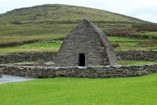
Gallarus Oratory, an early Christian church, built 1200-1300 years ago
One of our favorite things we did - pulled off on a scenic overlook, noticed a trail heading to the rocks on the clifftop, and went for a short trail-hike to what we think is Ireland's westernmost point (other than a few small islands off the coast) - next stop, Newfoundland.
View of the Blasket Islands
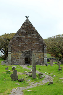
Kilmalkedar Church, built in the 1100s. The post in the foreground (with the hole in the top of it) is an Ogham stone, a post inscribed using early Irish language. The stone pre-dates the church by 700 or more years.

Hanging in An Daingean

The next leg of our journey was our favorite - we spent two nights slowing down, staying in the town of Dingle and exploring the Dingle Peninsula. The region is a Gaeltacht area, a place with heavy emphasis on the Gaelic language and traditions with government subsidies to help with the preservation. As such, road signs are in Gaelic, shop signs as well, and the Gaelic language is alive and well. This area was a favorite of ours, and our two night stay was all too brief. Dingle town has a lovely bay, several streets filled with colorful shops and restaurants, a number of artisans plying their trade, and the Dingle Peninsula, which is crowded with historical ruins. We spent half a day driving around looking like bobble heads as we came upon one spectacular view after another.

View from our Guesthouse's front yard
The rest of the day we spent enjoying the town, shopping for presents, having afternoon tea, strolling along the harbor, and in general, just enjoying being on vacation. Spending one day driving the Ring of Kerry and the next driving the Dingle Peninsula gave me such an appreciate of how the environment shapes my moods. I don't know that I've ever been so aware of this concept as I was in this region. The Ring of Kerry was full of steep hills, turbulent waters, and sharp curves around the cliffs, and I found my mood reflecting all that, full of tension and up and down emotions, a general sense of feeling unsettled. In contrast, the Dingle Peninsula is one of gentle, rounded hills, rolling green to the calm blue waters, the road curves softly through the hills, and my mood mirrored this landscape with tranquility and calmness. What a lovely chance to unwind and relax.
In the pub; we particularly liked the guy sleeping in the corner.
Just one of many interesting shopfront decorations
View of Dingle town from the marina

Sunday, August 28, 2011

It's Peat, Y'all!

Who hasn't wondered what the heck peat looks like. Here you go:

Saturday, August 27, 2011

Could You Drive This?

Extreme kudos go to Nathan. He was an awesome driver. He did need my help, whether he admits it or not. After all, who doesn't drive better when they have a passenger screaming in their ear? You may have thought I've been exaggerating about the Irish roads. I have not. I have pictures to prove it.

This is the main road around the Dingle Peninsula.
Main road on the Skellig Michael Ring of the Ring of Kerry (thankfully, this is one of the roads tour buses do not drive)
An actual road, not a driveway.
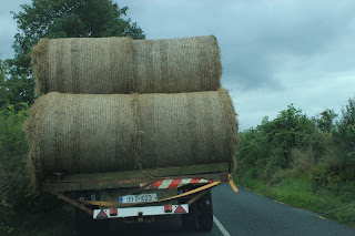
What you don't want to be stuck behind. Nathan actually managed to pass him...without tearing off any mirrors.
The intrepid driver himself and our trusty, little Clio.

Friday, August 26, 2011

Ring Forts of the Ring of Kerry

Photos of the amazing Ring Forts of the Ring of Kerry. For the blog text on our drive of the Ring, scroll down to the next post. There are no records of the Ring Forts original uses, prevailing theory is that they were used as a defensive retreat - as in, bring in the animals and the women (probably in that order) to protect against marauders. But maybe they were homes of powerful chieftans...or maybe ceremonial...or maybe storehouses.

Staigue Ring Fort, our first and the most dramatic, set in such a remote place
Staigue Ring Fort from the inside - I especially liked how the curve of the stone coincidentally mirrored the curve of the surrounding hills
Ring Fort Cahergall
A bonus with Cahergall and Leacanabuaile was we could walk on top of the walls - views of the sea, castle ruins (the one from the Coke machine picture), and another ring fort, what a neat experience
Ring Fort Leacanabuaile - this one has an underground passage

Ring of Kerry

We were traveling with a Rick Steves' guidebook, as we often do. His guidebooks have great walking and site tours in them, which are generally spot on. Everything we'd read from all sorts of sources talked about the challenges of driving the Ring of Kerry with all the tour buses. I can't emphasize enough how narrow a lot of the roads are (in fact, I think I'll do a separate blog post on it), and with the Ring of Kerry being a top item on every tour coach itinerary, and with just enough driving under our belt to be terrified (me only, Nathan actually seemed pretty calm), I wanted to follow Rick's advice and leave Kenmare by 8:30am. The idea is to drive the ring in the opposite direction as all the tour buses (which drive it counter-clockwise), get to the halfway point by 10:30am and turn off the main road onto a smaller ring road going to the tip of the peninsula. By spending a few hours in this area, on roads too small for the large buses, all those buses pass by the midpoint and get to the section you've already driven, leaving the upper part of the ring free and clear. You may wonder why all the tour buses drive in the same direction? Because the roads are too narrow for two buses to pass one another, so they all have to drive in the same direction, one behind the other, just like Mary's little lambs. I am here to tell you that yet again, "Ricky," as we like to call him, was dead right. We left our B&B late by 20 minutes (remember, we stayed at the pub until 1am listening to totally awesome music) and made a couple of extra stops. Sure enough, we ran into tour buses coming from the opposite direction when we were still 30 minutes from our turn off. Darn that Ricky. Why is he always right? We had a harrowing half hour, and I have a vague recollection of the final five minutes spent in out loud prayer. But I've blocked out as much as possible of that part of our trip.

The Ring of Kerry is wild and sharp, and the day we drove it, the weather mirrored the landscape. Clouds rolled in and out, water frothed at the base of jagged cliffs, hills really are the color of emeralds, and we clambered around large, ring forts built approximately 2000 years ago (actual time of construction estimates have an 800 year swing). The ring forts are impressive, and in a marked break from our general appreciation of Ricky, we much preferred Staigue Ring Fort, the closest one to Kenmare. First of all, we were the first visitors of the day and had the entire place to ourselves. Second, it was the least reconstructed of the three we visited, and I enjoy seeing how these places weather time and nature. Third, it was early enough in the day that we weren't jaded yet on impressive views. I'm adding the photos of the Ring Forts as a separate post rather than in this one because I wanted to share several pics.

Off the tip of the Ring of Kerry, or the edge of the world, as it was known up until just a few centuries ago,  is the steep, jagged island of Skellig Michael. Here, sometime in the 600s (AD), and for the next 500 or so years, a very small community of monks lived in relative isolation in order to grow closer to God. They ate sea birds and fish, lived in stone beehive huts they built (look like teepees, only built of stacked stone), chiseled steps into the steep, cliff face reaching 600 feet from sea to tip (where their huts were), and managed to fend off Viking invaders for a couple of centuries. While there was much about Ireland that captured my attention and gave me a desire to return, none more so than the chance to visit Skellig Michael one day. The trip depends heavily on the weather and requires at least one overnight in a tiny town with little to offer, so we skipped it this time, but, as has become my constant refrain, we'll have to return to visit.

St. Finan's Bay, with Skellig Michael in the distance
Ring of Kerry views - easy to see why Ireland is called the Emerald Isle
You may have to enlarge photo to see what's so cool about it - castle ruins in the backyard and Coke machine in the front.
Right in center of photo, you can make out a Ring Fort (don't know the name of it)
On the advice of our B&B proprietor, we took the turn off for the beautiful, Derrynane Beach...came across this fantastic house.

Thursday, August 25, 2011

You've Never Heard A Banjo This Good


Before heading into the larger towns of Galway and Dublin, we spent a few days on Ireland's west coast, driving the Ring of Kerry and Dingle Peninsula. We picked Kenmare as our gateway town rather than Kilkenny, mainly because Kenmare is smaller, quainter, and sounded like our kind of town. After our relaxing drive into Kenmare, we got checked into our B&B, Abbey Court, and quickly headed into town before all the businesses closed up for the evening. Kenmare has a small lace museum over it's Tourist Information office, several Irish goods stores, and the town has their very own stone circle, located only a five minute walk past the main drag. Awesome!

The grounds were so well kept that it basically looked like a really cool rock garden, complete with a funky, offering type tree with lots of hair ties around it's branches. Fifteen stones ring a boulder thought to be a burial monument, and of course, it's aligned with the sun. There are over 100 stone circles located just in this southwestern area of Ireland, and most date back to sometime from 500-2000 BC. You'll see in the photo that there are no other tourists walking around. We found this to be the case everywhere (except at the Cliffs of Moher, and you'll hear plenty about THAT), despite the fact that August is the highest tourist month. Despite full hotels, restaurants, and shops, and the fact that we were on a fairly popular and common tourist track, we found that we really could have sites to ourselves, wandering around, taking photos to my heart's delight. Just one more thing to love about Ireland.

We wandered around town a bit, chatted with shopkeepers, ate another great meal, and following the recommendation of our B&B owner, headed over to Coachman's Pub to hear Michael O'Brien play. Absolutely the best music experience of our entire trip. He and his fellow musicians on stage with him that night (singer, Catryn (sp?) and a banjo player, name unknown) were fantastic. So much so that we stayed from start to finish...at 1am! And this was the night before the one day of our trip that we absolutely had to get an early start (to avoid the tour buses on the Ring of Kerry) - that's a testament to how good the music was. You know how sometimes you have a fun time, and later, you remember that you had fun, but can't really recall the actual sights, sounds, feels. This moment, for me, was one of those recall moments where I can close my eyes, think of sitting in the Coachman's, and I can feel everything again - I see the low light and the musicians doing what they were born to do, I taste the Bulmer's cider that I sipped all night, I hear the music again, I feel the excitement in the air from the other people in the room enjoying the moment as much as we were. It's one of the few moments of this trip that I can so clearly remember, and what a good memory it is.

[Edit: As it turns out, we weren't listening to Michael O'Brien after all. He's probably a great musician, but we wouldn't know. Now we have another reason to return to Kenmare! Thank you, Siobhan, from Coachmans Townhouse, for the below comment and correction. Musicians were Sean O'Connor, Sean Murphy, and Cathernine, Teahan.]

Wednesday, August 24, 2011

Ireland's Southern Coast

Having been in Ireland for only 24 hours and already feeling like we'd experienced an entire vacation, I just got more excited for the adventures in store. We headed to the lovely, small town of Kinsale for our second night. Kinsale is a beautiful, small port town with a history of human habitation back to the Stone Age. But in more modern times, ten miles off of Kinsale is where the Lusitania was torpedoed. We stayed at what ended up being our favorite B&B for the whole trip, Cloisters B&B, a recently redecorated gem of a place. Our stay was all too brief since we'd spent a little extra time at the Old Midleton Distillery, and we were headed on to another town the following morning. But we enjoyed walking around Kinsale in the evening, had a great dinner, and headed for our nightly, pub music ritual. The pubs in town were packed with music that was a little more screechy than we like, but we finally stumbled upon a pub with great music coming out of it and only four people sitting around listening. We scored a front row table and spent an enjoyable hour, during which time only four more people came in. We were even more confused by the lack of patrons when we walked back to the B&B and saw all the crowds spilling out of every pub. No matter, we gained.

Leaving all too early the next morning, we took the coastal route along the southwestern coast, as our B&B proprietor suggested. This took us right by the Dromberg Stone Circle, a set of 17 standing stones (ala Stonehenge, but not as big) that mark the winter solstice. There are also the remains of a hut and a really neat cooking pit in which heated rocks were placed to boil water, and experiments have shown the water stays hot for three hours. The stone circle sits in the middle of the countryside, with fields and hills stretching out. As happens in Italy, my thoughts turned to the people who once lived in the hut. What was the stone circle really for? Who lived in the hut? What was their landscape like then? But then the rain started back up and we rushed back to the car.

Lunch was a quick stop in the colorful, seaside town of Bantry. We found out that about 35 years ago, Ireland had a "Tidy Town" competition, so lots of towns painted their white buildings bright colors. That trend apparently stuck, and every town we visited was chock full of charm with vibrantly colored main streets and fun, painted advertisements on the sides of buildings. 

We had no idea our route was taking us over a mountain range until we found ourselves in the most beautiful, mountain pass and driving through tunnels cut into the mountain - rough hewn tunnels with waterfalls pouring down their sides. Thankfully, the road was very quiet with little oncoming traffic, so Nathan was able to enjoy the view as well. We'd planned to stop at a sheep farm on our way, but as we left the B&B in the morning, we decided that rather than filling the day with multi-hour stops, we preferred to meander, stop at scenic overlooks, have a leisurely lunch, and literally, slow down to enjoy the ride.

Tuesday, August 23, 2011

Whiskey Rocks - or Rather, Seeing the Rock and Drinking Some Whiskey

Our first tourist site to visit was the Rock of Cashel, which oddly, is actually a big, ruined church. I suppose the actual Rock is the big hill the church stands on, but these days, the Rock of Cashel refers to the actual ruins. This place (the rock, not the church) was the seat of the old kings of Ireland for about 800 years, but as there was loads of clan warfare, Murtagh O'Brien handed the rock over to the church about 1100. What happens when you give really good stuff to the church? Influence. Smarty O'Brien landed himself power within the church AND kept his land out of the hands of his main rival. My favorite description of him is this phrase from Wikipedia: "self-declared High King of Ireland." I just love declaring oneself the High King, or Queen, as it were. I'll have to keep this practice in mind.

Rock of Cashel has some beautiful ruins, set atop a hill and visible for miles.  The cathedral has an arched ceiling in places, and in others, open sky. It's rose window frame makes a filigree against the sky, and it's graveyard is filled with Celtic crosses over the scattered graves. This was our first look at a gathering of the Celtic crosses, and what an evocative sight! Standing on the Rock, with the crosses surrounding us, we were buffeted by the wind as we looked out over the brilliant, green countryside and the storm clouds rolled in. But in a race to get to Old Midleton Distillery, down in County Cork, before the final tour of the day, we didn't have time to sit and reflect, or even stop for a little pot of tea, which we quickly found to be quite restorative in our rushed days. The town of Cashel itself looked so charming, and I found out on our return to Italy and after a conversation with my sister that Cashel was one of her favorite towns as a study abroad student a few years ago.
One happy guy
The Old Midleton Distillery was great fun. We arrived just in time for the second to last tour (which turned out to be vital since that meant time for a little taste test and shopping at the end) and got to see things like the oldest, copper still in the world (holds over 30,000 gallons). This distillery once made Paddy's Whiskey, but when the company merged with Jameson's in the 1970s, the distillery was closed and operations moved right next door. Now, every single drop of Jameson's in the entire world is produced at the next door facility. Pretty cool, as was our sample at the end.
Aging Whiskey
We quickly realized that this trip needed to be an overview tour, and one day, we'll have to return to Ireland for a longer period of exploration. Every single day brought new places in which there was never enough time to see and do it all...but boy did we try.