Monday, August 29, 2011

More Photos of Dingle Peninsula

Writeup on Dingle is in post below. Here are the photos from our Dingle Peninsula Loop drive.
Beehive Huts dot the landscape. They date to the Early Christian period, and were generally farmsteads - fence enclosures kept livestock in, and a number of huts operated as family homes, farm buildings, and storage huts.
Just past the fencepost, the grass is a little darker green - and in the shape of a circle. This is an unexcavated remnant of a ringfort dating to 500 B.C.
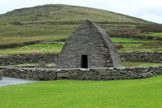
Gallarus Oratory, an early Christian church, built 1200-1300 years ago
One of our favorite things we did - pulled off on a scenic overlook, noticed a trail heading to the rocks on the clifftop, and went for a short trail-hike to what we think is Ireland's westernmost point (other than a few small islands off the coast) - next stop, Newfoundland.
View of the Blasket Islands
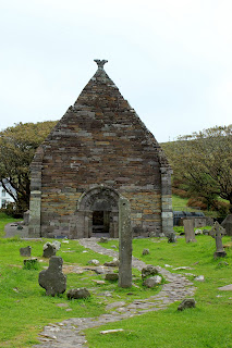
Kilmalkedar Church, built in the 1100s. The post in the foreground (with the hole in the top of it) is an Ogham stone, a post inscribed using early Irish language. The stone pre-dates the church by 700 or more years.

No comments:

Post a Comment